San Antonio Maps and Orientation
(San Antonio, Texas - TX, USA)
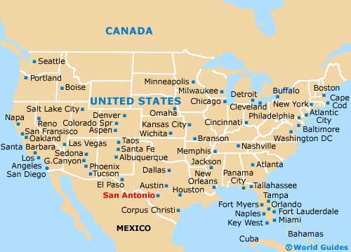
Lying on the southern side of Texas, within the American Southwest and just under two hours away from
Austin, the city of San Antonio comes with a bustling downtown district and plenty of sightseeing attractions. San Antonio is currently one of America's biggest and fastest-growing cities.
The city functions as the county seat of Bexar County, while elements also reside within the counties of Comal and Medina. Those prepared to travel will find that
Houston and
Dallas are within driving distance, being found some 200 miles / 322 km east and 275 miles / 443 km north respectively.
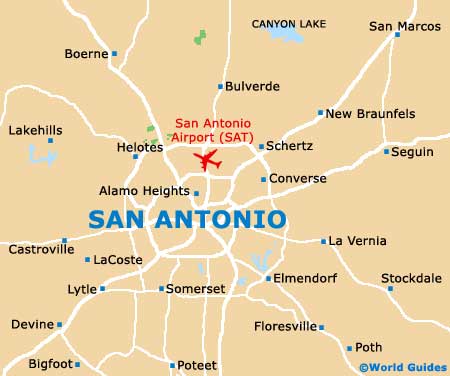
The center of downtown San Antonio is to be found at the point where Losoya Street and Commerce Street meet. This is also where you will find the popular Riverwalk trail, while the Alamo district resides close by, to the northeast.
Maps and Orientation of the City
Two major highways run either side of San Antonio city center - Interstate I-35 (Pan Am Expressway) to the west and Interstate I-37 (US-281) to the east. The entire city is encircled by a giant loop of main roads, which include Interstate I-410 and the Charles W. Anderson Loop.
Free maps of San Antonio can be sourced at the Visitors Center on the Alamo Plaza stretch, which is to be found close to the Hyatt Hotel, and in between the Ripley's Haunted Adventure and the Ripley's Believe It Or Not attractions. Trolley tours can also be booked here, or you can simply head across the street to check out the historic Alamo Mission, site of the 1836 Battle of the Alamo.
- Austin - 80 miles / 129 km (one hour and 55 minutes, northeast)
- Bulverde - 26 miles / 42 km (45 minutes, north)
- Government Canyon State Natural Area - 25 miles / 40 km (40 minutes, west)
- Guadalupe River State Park - 41 miles / 66 km (one hour and five minutes, north)
- Helotes - 20 miles / 32 km (35 minutes, northwest)
- Hondo - 41 miles / 66 km (one hour and five minutes, west)
- Jourdanton - 38 miles / 61 km (one hour, south)
- New Braunfels - 33 miles / 53 km (50 minutes, northeast)
- Pipe Creek - 40 miles / 64 km (one hour and five minutes, northwest)
- Pleasanton - 36 miles / 58 km (55 minutes, south)
- Scenic Oaks - 27 miles / 43 km (45 minutes, northwest)
- Seguin - 38 miles / 61 km (one hour, east)
- Spring Branch - 37 miles / 60 km (one hour, north)
- St. Hedwig - 26 miles / 42 km (45 minutes, east)
- Timberwood Park - 25 miles / 40 km (40 minutes, north)
- Universal City - 20 miles / 32 km (35 minutes, northeast)
Map of the United States
Map of Texas

Map of San Antonio